
Introduction / Issue
Think of a delivery company trying to show ten thousand stops on a map, or a utility company mapping every pipeline in a city. It works fine with a few dozen points. But once you get into the thousands, most maps start to struggle – panning gets jerky, zooming lags, and the browser slows down.
This is the classic performance wall enterprise developers hit when visualizing spatial points, pipelines, or delivery routes at scale. The traditional culprit is payload size: every geometry, at every zoom level, is shipped to the browser in one heavy JSON or image payload — whether the user is looking at it or not. The result is slow initial loads, laggy interactions, and a frustrating user experience that undermines an otherwise well-built application.
Why We Need to Do / Cause of the Issue
Historically, teams solved spatial rendering with hand-built JavaScript integrations — wiring up third-party mapping libraries, parsing raw GeoJSON feeds, and manually managing layers, tiles, and redraw cycles. Every one of those integrations is custom code that has to be maintained, patched, and re-tested every time a browser or library updates.
Two structural issues compound the problem:
- Unbounded payloads: without viewport-aware filtering, the application downloads spatial data for the entire dataset instead of only the region currently visible on screen.
- CPU-bound rendering: raster tiles and canvas-drawn geometries lean on the CPU, so as feature counts grow, frame rates collapse and the map becomes unresponsive during pan and zoom.
Developers need a clean, native, declarative way to render map geometries directly on the client GPU while fetching only the spatial data visible within the current viewport — without writing or maintaining a single line of custom mapping JavaScript.
How Do We Solve
Oracle APEX solves this natively through declarative Map Region attributes: Vector Tiles and Bounding Box filtering. Vector tiles package geometry as compact, GPU-renderable instructions instead of pre-rendered raster images, so the browser draws crisp points, lines, and polygons at any zoom level using hardware acceleration. Bounding box filtering complements this by asking the database for only the rows that intersect the user’s current viewport — so panning across a city never means downloading the whole country.
Together, these two features move spatial performance out of custom JavaScript entirely and into the same declarative Property Editor developers already use for the rest of an APEX page.
Why this matters
Faster first paint: only the visible bounding box is fetched, not the entire dataset.
Smoother interaction: GPU-rendered vector tiles keep pan/zoom fluid even with thousands of geometries.
Zero extra JavaScript: no external mapping libraries or custom parsers to install or patch.
Manual Js Vs Declarative APEX
| (Manual JS) | (Declarative APEX) |
| Hand-rolled JavaScript to parse external map feeds and raw GeoJSON structures. | Point APEX at a spatial table — geometry rendering is fully declarative. |
| Entire payload (every geometry, every zoom level) shipped to the browser at once. | Vector tiles stream only what the current viewport bounding box needs. |
| Rendering handled on the CPU via custom canvas/SVG drawing logic. | Geometry rendering offloaded to the client GPU for buttery-smooth pan/zoom. |
| Fragile: breaks on library upgrades, browser quirks, and large datasets. | Maintainable: a handful of Property Editor toggles, no external dependencies. |
Real-Time Scenario & Step-by-Step Implementation
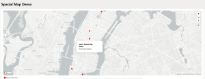
Imagine a facilities team that needs to visualize thousands of asset locations across New York City, color-coded by category, with instant tooltips on hover. Here is how to build it natively in APEX, end to end.
Step 1 — Create the Page and Point It at a Map Source
- Create a new page and add a Map Region.
- Source Table→ DEMO_MAP_LOCATION
- Source Type→ Table
- Map Style → Points
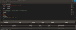
- After creating the table and inserting records create a spacial index.
CREATE INDEX DEMO_MAP_LOCATION_SPATIAL_IDX
ON DEMO_MAP_LOCATION(GEOMETRY)
INDEXTYPE IS MDSYS.SPATIAL_INDEX_V2;
- Geometry is an internal Object datatype in Oracle where the geometry values must be converted to geojson format.
SELECT location_id,
name,
category,
SDO_UTIL.TO_GEOJSON(geometry) AS geometry_json
FROM demo_map_location;
Step 2 — Configure the Map Geometry Settings
- Geometry Column→ select GEOMETRY
- Color Value Column→ CATEGORY (or leave blank for a single color)
- Tooltip Column→ NAME
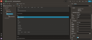
Step 3 — Set the Initial Viewport
- Select the Map Region → Property Editor → Attributes
- Under Initial Position, set Zoom to Static.
- Set the default coordinates: Latitude 7128, Longitude -74.0060, Zoom Level 11or 12.
- Set the Bounding Box type to ‘Static Values’ and give the min and Max longitude and latitude values.
Min Longitude: -74.25
Min latitude: 40.49
Max Longitude: -73.70
Max latitude: 40.91
Step 4 — Turn On Vector Tiles
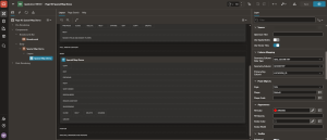
- Open the Layerssection in the left-hand pane.
- Enable the “Use Vector Tiles”toggle in the Property Editor.
Step 5 — Guard Against Infinite Loops and Set the Row Key
- Return to the Region’s right-hand controls and uncheck Infinite Loop.
- Set Primary Key Columnto LOCATION_ID so APEX can track each geometry reliably during re-renders.
Step 6 — Configure the Layer Info Window
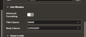
- Under Layer → Info Window, set Title Column→ NAME.
- Set Body Column→ CATEGORY so users get instant context on click or hover.
Conclusion
By adopting APEX’s native Map Region attributes — Vector Tiles for GPU-accelerated rendering and Bounding Box filtering for viewport-aware data loading — teams eliminate the need for hand-written, fragile JavaScript mapping integrations altogether. Geometries render instantly, payload sizes drop drastically, and users get a fluid, responsive geospatial experience on any device, from a laptop dashboard to a tablet in the field.
The bigger win is architectural: spatial visualization becomes a declarative, low-code capability instead of a specialized JavaScript discipline — meaning any APEX developer, not just a mapping specialist, can ship enterprise-grade geospatial applications.
